Ashraf Engineer
February 8, 2025
EPISODE TRANSCRIPT
Hello and welcome to All Indians Matter. I am Ashraf Engineer.
Fresh tension has been infused into India’s very edgy relationship with China. China is proceeding with the construction of the world’s largest dam, which is also the planet’s biggest infrastructure project, costing $137 billion, on the Yarlung Zangbo river in Tibet. It is three times the size of the Three Gorges Dam and will be located in one of the deepest gorges on Earth.
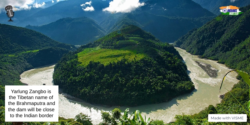
Yarlung Zangbo is the Tibetan name of the Brahmaputra and the dam is close to the Indian border. The gorge on which the dam will be built is where the Brahmaputra makes a big U-turn to flow into Arunachal Pradesh and then on to Bangladesh.
With China already operationalising the Zam Hydropower Station, the largest in Tibet, in 2015, India is concerned that the dam on the Brahmaputra will enable China to control or divert water flow into India and release massive amounts to flood border areas if hostilities break out. The Lowy Institute, an Australian think tank, said in a 2020 report that control over rivers in the Tibetan plateau effectively gives China a chokehold on India’s economy.
China’s foreign ministry responded to India’s concerns by asserting that China had a right to dam the river and had considered all downstream impacts.
India’s concerns are not out of place. China has in the past built at least 11 dams over the Mekong river that have caused severe droughts in neighbouring Vietnam, Laos and Thailand.
SIGNATURE TUNE
Let’s consider how the dam will work and also the strategic nature of the Brahmaputra.
The lower reaches of the project feature a vertical drop of 2,000 metres stretching over a 50k-m distance. This represents a potential of 70 million kilowatts. To put it in perspective, that’s more than three Three Gorges Dams, which has an installed capacity of 22.5 million kilowatts. To harness this hydro power, four to six 20-km-long tunnels would be drilled through the Namcha Barwa mountain to divert half of the river’s flow at about 2,000 cubic metres per second.
The Brahmaputra can be viewed as a Himalayan river basin that spans four countries. China is the uppermost; India and Bhutan come next and finally Bangladesh. It is from Bangladesh that the river drains into the Bay of Bengal. All these countries have major water projects planned or operational in the river basin. These include hydropower dams, embankments for river control, irrigation dams and barrages.
These are also seen as projections of national power – symbols of countries’ control over natural resources. China has complete control over Tibet’s rivers and deploys hydropower development as it sees fit. So, the Three Gorges Dam on the Yangtze river and the Zangmu Dam on the Yarlung Zangbo are often positioned as state symbols by the political leadership.
The grandstanding apart, there are serious environmental concerns around the latest Yarlung Zangbo project. Experts have pointed out that the 60 GW project lies in an earthquake fault zone. They have said that there are real risks of flooding and structural collapse, particularly in the event of an earthquake. In fact, just two weeks after China announced the project in late December 2024, Tibet suffered a massive 6.8 magnitude earthquake that killed 126 and injured 180. That was followed two days later by a 5.5 magnitude aftershock. The epicentre was 1,200 km from the dam site but, environmentalists say, the entire region has suffered a series of quakes in the past few decades. The Tibetan plateau frequently experiences earthquakes because it is located over tectonic plates.
Beijing simply said that the project was safe and prioritised ecological protection.
India’s foreign ministry has conveyed its concerns to Beijing, which includes a protest about the creation of two new counties – one of which includes a disputed area claimed by India.
Let’s not forget that relations between the two countries have been strained after deadly border clashes in 2020. While an agreement to pull troops back was reached and there has been diplomatic progress since then, both sides are wary.
Coming back to the river projects, India and China established the Expert Level Mechanism in 2006 to deal with issues related to trans-border rivers. Under this mechanism, China provides India with hydrological information on the Brahmaputra and Sutlej during flood seasons. This data sharing figured in talks between India’s National Security Advisor Ajit Doval and Chinese Foreign Minister Wang Yi last December.
Other than the ecological and security concerns, the dam could also impact communities living along the river system. These communities adapted as the river shaped and shifted over the centuries but, dams built by China, India and Bhutan, mean that these communities cannot use their traditional knowledge about the river system meaningfully. The projects have affected traditional livelihoods in Tibet as well as India, Bhutan and Bangladesh.
The perennial downstream flow of the Brahmaputra into India and Bangladesh depends on the flow of the Yarlung Zangbo. Its blocking, so that China can operate the dam, will change surface water levels, monsoon patterns and groundwater systems. This, too, will affect downstream agrarian communities. There is also a fear that the dam could displace them.
China has built several dams in Tibet, which it annexed in the 1950s. The dams are viewed as an example of Beijing’s exploitation of Tibetans and their land. Not too long ago, the Chinese government arrested hundreds of Tibetans who were protesting against the Gangtuo Dam project. Many of them were beaten and seriously injured.
The Gangtuo Dam would displace several villages and submerge ancient monasteries that are home to sacred Buddhist relics. Bejing claimed it had relocated and compensated locals, and moved the relics to safety.
As far as the Yarlung Zangbo dam is concerned, China has not said how many people it would displace. For perspective, the Three Gorges Dam necessitated the resettlement of 1.4 million.
Tibet’s river systems are critical not just to China, India, Bhutan and Bangladesh, but also to the Earth’s cryosphere. It comprises permafrost and glaciers, and systems directing climate and precipitation pathways such as the monsoon. As the climate changes, what are known as Glacial Lake Outburst Floods have gotten more frequent in the Himalayas. This was brought into focus with the Chungthang Dam collapse in Sikkim in October 2023. The collapse devastated life and property in downstream communities.
The dams being built now are essentially a territorialisation of river systems and it breaks their natural evolution. This, in turn, affects agricultural and pastoral communities, the ecology and wetland systems. If such construction continues, the Brahmaputra basin will go from ethereal landscape to worrying risk-scape.
Thank you all for listening. Please visit allindiansmatter.in for more columns and audio podcasts. You can follow me on Twitter at @AshrafEngineer and @AllIndiansCount. Search for the All Indians Matter page on Facebook. On Instagram, the handle is @AllIndiansMatter. Email me at editor@allindiansmatter.in. Catch you again soon.